
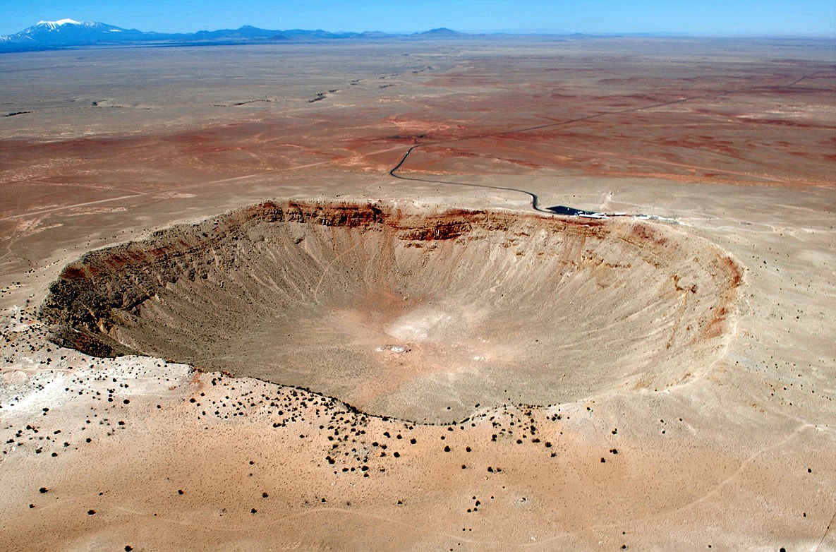
1. Meteor Crater, Arizona; The crater was created about 50,000 years ago during the Pleistocene epoch when the local climate on the Colorado Plateau was much cooler and damper. At the time, the area was an open grassland dotted with woodlands inhabited by woolly mammoths and giant ground sloths.
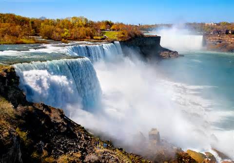
2. Niagara Falls
Niagara Falls were formed when glaciers receded at the end of the Wisconsin glaciation, (the last ice age), around 11,000 years ago and water from the newly formed Great Lakes carved a path through the Niagara Escarpment en route to the Atlantic Ocean.
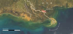
3. Mississippi River Delta
The latest cycle of delta movement can be traced to the Pleistocene epoch, when a large amount of ocean water was tied up in glaciers. The sea level was 300-400 feet (~100m) below present level, and causing the mouth of the Mississippi to be located further out into the Gulf of Mexico. 10,000 years ago, the glaciers began to melt, and the sea level began to rise. 5,000 – 6,000 years ago, the sea level stabilized, and formation of recognizable modern deltas began.
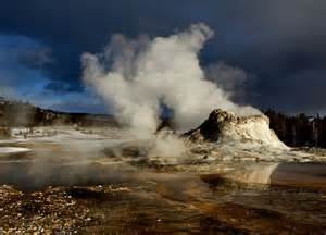
4. Yellowstone
The current caldera was created by a cataclysmic eruption that occurred 640,000 years ago, which released more than 1,000 km³ (240 cubic miles) of ash, rock and pyroclastic materials. This eruption was more than 1,000 times larger than the 1980 eruption of Mount St. Helens. It produced a caldera nearly five eighths of a mile (1 km) deep and 45 by 28 miles (72 by 45 km) in area and deposited the Lava Creek Tuff, a welded tuff geologic formation. The most violent known eruption, which occurred 2.1 million years ago, ejected 588 cubic miles (2,450 km³) of volcanic material and created the rock formation known as the Huckleberry Ridge Tuff and created the Island Park Caldera. A smaller eruption ejected 67 cubic miles (280 km³) of material 1.3 million years ago, forming the Henry’s Fork Caldera and depositing the Mesa Falls Tuff.
5. Appalachian Mountains
The Appalachians first formed roughly 480 million years ago during the Ordovician Period and once reached elevations similar to those of the Alps and the Rocky Mountains before they were eroded.

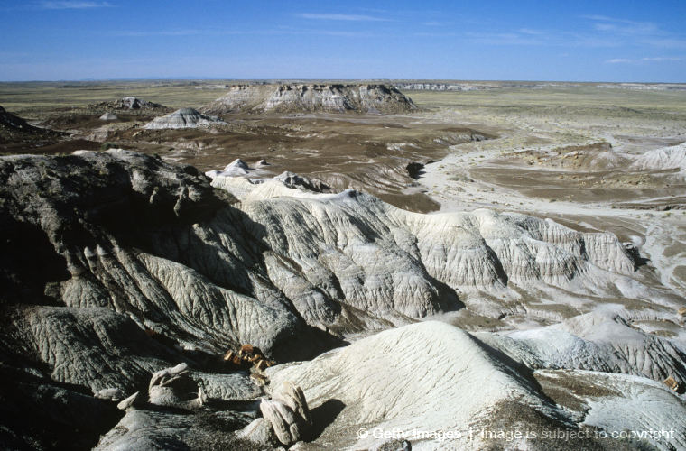
6. Grand Canyon
The Grand Canyon is part of the Colorado River basin which has developed over the past 40 million years.The canyon is the result of erosion which creates one of the most complete geologic columns on the planet. The major geologic exposures in the Grand Canyon range in age from the 2-billion-year-old Vishnu Schist at the bottom of the Inner Gorge to the 230M-year-old Kaibab Limestone on the Rim. There is a gap of about a billion years between the 500M-year-old stratum and the level below it, which dates to about 1.5 billion years ago. This large unconformity indicates a period of erosion between two periods of deposition.
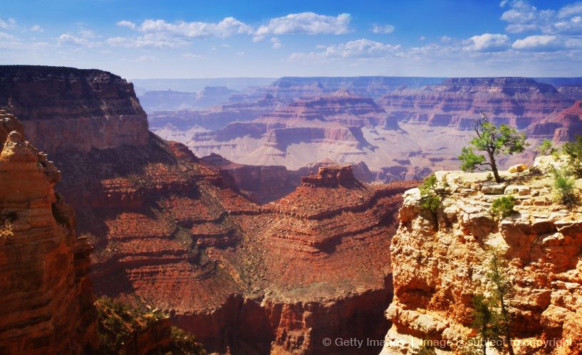
Many of the formations were deposited in warm shallow seas, near-shore environments (such as beaches), and swamps as the seashore repeatedly advanced and retreated over the edge of a proto-North America. Major exceptions include the Permian Coconino Sandstone, which contains abundant geological evidence of aeolian sand dune deposition. Several parts of the Supai Group also were deposited in non–marine environments.
The great depth of the Grand Canyon and especially the height of its strata (most of which formed below sea level) can be attributed to 5–10 thousand feet (1,500 to 3,000 m) of uplift of the Colorado Plateau, starting about 65M years ago (during the Laramide Orogeny).
The base level and course of the Colorado River (or its ancestral equivalent) changed 5.3M years ago when the Gulf of California opened and lowered the river’s base level (its lowest point). This increased the rate of erosion and cut nearly all of the Grand Canyon’s current depth by 1.2M years ago. The terraced walls of the canyon were created by differential erosion. Between 100,000 and 3M years ago, volcanic activity deposited ash and lava over the area which at times completely obstructed the river. These volcanic rocks are the youngest in the canyon.
7. Mt. St. Helens
Mount St. Helens is geologically young compared with the other major Cascade volcanoes. It formed only within the past 40,000 years, and the pre-1980 summit cone began rising about 2,200 years ago. The volcano is considered the most active in the Cascades within the Holocene epoch (the last 10,000 or so years).

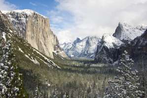
8. Yosemite
The geology of the Yosemite area is characterized by granitic rocks and remnants of older rock. About 10 million years ago, the Sierra Nevada was uplifted and then tilted to form its relatively gentle western slopes and the more dramatic eastern slopes. The uplift increased the steepness of stream and river beds, resulting in formation of deep, narrow canyons. About 1 million years ago, snow and ice accumulated, forming glaciers at the higher alpine meadows that moved down the river valleys. Ice thickness in Yosemite Valley may have reached 4,000 feet (1,200 m) during the early glacial episode. The downslope movement of the ice masses cut and sculpted the U-shaped valley that attracts so many visitors to its scenic vistas today.
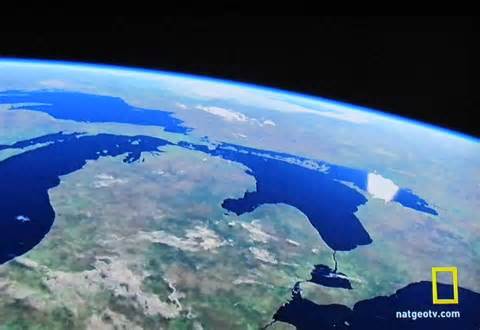
9. Great Lakes
The Great Lakes began to form at the end of the last glacial period around 10,000 years ago, as retreating ice sheets carved basins into the land and they became filled with meltwater.
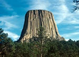
10. Devils Tower
The igneous material that forms the Tower is a phonolite porphyry intruded about 40.5 million years ago, a light to dark-gray or greenish-gray igneous rock with conspicuous crystals of white feldspar. As the magma cooled, hexagonal (and sometimes 4-, 5-, and 7-sided) columns formed. Devils Tower did not visibly protrude out of the landscape until the overlying sedimentary rocks eroded away. As the elements wore down the softer sandstones and shales, the more resistant igneous rock making up the tower survived the erosional forces. As a result, the gray columns of Devils Tower began to appear as an isolated mass above the landscape.
11. Badlands
The badlands formations in Badlands National Park, South Dakota, underwent a 47-million year period of deposition which spanned three major geologic periods (the Cretaceous Period, the Late Eocene, and the Oligocene Epochs), resulting in clear, distinct layers of sediment which serve as a dramatic display of the law of superposition. Once the deposited sediments have solidified, the sedimentary material becomes subject to erosion. It is sometimes erroneously taught that badlands erode at a steady rate of about 1 inch per year. In actuality, the precise processes by which the erosion responses take place vary depending on the precise interbedding of the sedimentary material. Researchers at Badlands National Park are currently concluding a 3-year project to learn more about actual erosion rate of the specific badlands found in that park.
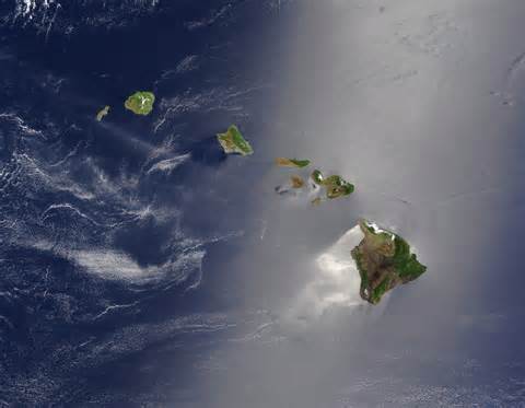
12. Hawaii
The chain of islands or archipelago formed as the Pacific plate moved slowly northwestward over a hotspot in the Earth’s mantle at about 32 miles (51 km) per million years. Hence the islands in the northwest of the archipelago are older and typically smaller, due to longer exposure to erosion. The age of the archipelago has been estimated using potassium-argon dating methods. From this study and others it is estimated that the northwestern most island, the Kure Atoll, is the oldest at approximately 28 million years (Ma); while the southeastern most island, Hawaiʻi, is approximately 0.4 Ma (400,000 years). The only active volcanism in the last 200 years has been on the southeastern island, Hawaiʻi, and on the submerged but growing volcano at the extreme southeast, Loʻihi.
These are just a dozen familiar formations on earth of literally millions one could display where the geology has been worked out in great detail over the past 150 years using dozens of dating methods and thousands of comparative geological, biological, paleontological, and archaeological studies which have confirmed the age of these locations beyond any reasonable doubt.
The data presented here were drawn from individual Wikipedia articles, easily accessed by anyone wishing to see excellent summaries of what we do know about our Earth. The wikis include just a representative sampling of the voluminous references detailing our knowledge of the age and formation of these landmarks.
The average Xian who has been sold the absurd fantasy of a “young earth” only 6,000 years old, doesn’t realize the enormity of the science that must be totally wrong for that insane lie to be true.
Ken Ham and Ray Comfort count on the hope that anyone who buys their preposterous fantasy will never research the science.
(5147)